Geolocate

Mackinaw topographic map

Click on the map to display elevation.

About this map
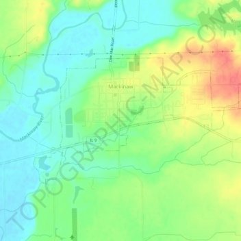
Name: Mackinaw topographic map, elevation, terrain.

Location: Mackinaw, Tazewell County, Illinois, 61755, United States (40.52130 -89.37596 40.54144 -89.32507)

Average elevation: 650 ft

Minimum elevation: 571 ft

Maximum elevation: 778 ft

Tazewell County trails, hiking, mountain biking, running and outdoor activities

Other topographic maps

Click on a map to view its topography, its elevation and its terrain.
Allentown

United States > Illinois > Tazewell County

Average elevation: 673 ft

Groveland

United States > Illinois > Tazewell County

Average elevation: 745 ft

Dillon

United States > Illinois > Tazewell County

Average elevation: 614 ft

Brock Lake

United States > Illinois > Tazewell County > Mackinaw

Average elevation: 617 ft

Gear up for your next adventure:

🧤Tactile Hiking Gloves - Keep hands warm while operating GPS and smartphone screens
🥾Women's Hiking Boots - Top-rated trail boots with ankle support and superior grip
🧥Men's Rain Shells - Premium waterproof and breathable jackets for mountain weather
🏔️Mountain Trail Maps - High‑detail maps for popular peaks
🏕️Tent Footprint - Protect your tent base from wear

As an Amazon Associate, this site earns from qualifying purchases at no extra cost to you.