Geolocate

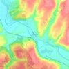
Milford topographic map

Click on the map to display elevation.

About this map
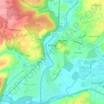
Name: Milford topographic map, elevation, terrain.

Location: Milford, Clermont County, Ohio, United States (39.15222 -84.30226 39.19191 -84.25081)

Average elevation: 614 ft

Minimum elevation: 479 ft

Maximum elevation: 869 ft

Clermont County trails, hiking, mountain biking, running and outdoor activities

Other topographic maps

Click on a map to view its topography, its elevation and its terrain.
Perintown

United States > Ohio > Clermont County

Average elevation: 653 ft

Cedron

United States > Ohio > Clermont County

Average elevation: 748 ft

The Highlands

United States > Ohio > Clermont County

Average elevation: 715 ft

Amelia

United States > Ohio > Clermont County

Average elevation: 869 ft

Sundale

United States > Ohio > Clermont County

Average elevation: 751 ft

Concord

United States > Ohio > Clermont County

Average elevation: 830 ft

The Highlands

United States > Ohio > Clermont County

Average elevation: 715 ft

Hills

United States > Ohio > Clermont County

Average elevation: 797 ft

Laurel

United States > Ohio > Clermont County

Average elevation: 827 ft

The Highlands

United States > Ohio > Clermont County

Average elevation: 715 ft

Saltair

United States > Ohio > Clermont County

Average elevation: 879 ft

The Highlands

United States > Ohio > Clermont County

Average elevation: 715 ft

Gear up for your next adventure:

🥇GPS Hiking Watch - Multi‑sport GPS watch with navigation and trail tracking
🏕️Tent Footprint - Protect your tent base from wear
📡Handheld GPS Device - Reliable handheld GPS for outdoor navigation
🧤Tactile Hiking Gloves - Keep hands warm while operating GPS and smartphone screens
💧Water Purification System - Clean water on the trail with reliable purifiers

As an Amazon Associate, this site earns from qualifying purchases at no extra cost to you.