Geolocate

Abeokuta topographic map

Click on the map to display elevation.

About this map
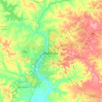
Name: Abeokuta topographic map, elevation, terrain.

Location: Abeokuta, Abeokuta South, Ogun State, 111101, Nigeria (7.00100 3.18800 7.32100 3.50800)

Average elevation: 312 ft

Minimum elevation: 43 ft

Maximum elevation: 719 ft

Other topographic maps

Click on a map to view its topography, its elevation and its terrain.

Olumo Rock

Nigeria > Ogun State > Abeokuta South > Abeokuta

Average elevation: 210 ft

Gear up for your next adventure:

🧢Outdoor Hiking Hat - Sun protection hat for outdoor explorers
🩹Survival Bandages - High‑quality bandages for emergencies
🧭Compass with Lanyard - Easy‑carry compass for navigation
💧Water Filtration Bottles - Safely drink from streams and lakes while exploring
🥾Hiking Shoes - Durable and comfortable shoes for trail hiking

As an Amazon Associate, this site earns from qualifying purchases at no extra cost to you.