
Make a donation
Gear up for your next adventure:
As an Amazon Associate, this site earns from qualifying purchases at no extra cost to you.
Cambre topographic map
Click on the map to display elevation.
Make a donation
Gear up for your next adventure:
As an Amazon Associate, this site earns from qualifying purchases at no extra cost to you.
Cambre
El relieve del municipio está caracterizado por el río Mero, su afluente el río da Brexa, y los montes que los rodean. Al sur destaca el monte Castro de Ameás (207 m). La altitud oscila entre los 250 m al suroeste y los 36 m en el embalse de Cecebre, en el límite con Abegondo. El pueblo se alza a 62 m sobre el nivel del mar.
Make a donation
Gear up for your next adventure:
As an Amazon Associate, this site earns from qualifying purchases at no extra cost to you.
About this map
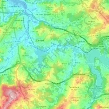
Name: Cambre topographic map, elevation, terrain.
Location: Cambre, La Coruña, Galicia, España (43.24040 -8.37747 43.32283 -8.28439)
Average elevation: 266 ft
Minimum elevation: 0 ft
Maximum elevation: 853 ft
Make a donation
Gear up for your next adventure:
As an Amazon Associate, this site earns from qualifying purchases at no extra cost to you.
Other topographic maps
Click on a map to view its topography, its elevation and its terrain.
Make a donation
Gear up for your next adventure:
As an Amazon Associate, this site earns from qualifying purchases at no extra cost to you.