
Thank you for supporting this site ❤️
Make a donation
Make a donation
Gear up for your next adventure:
As an Amazon Associate, this site earns from qualifying purchases at no extra cost to you.
Rialp topographic map
Click on the map to display elevation.
Thank you for supporting this site ❤️
Make a donation
Make a donation
Gear up for your next adventure:
As an Amazon Associate, this site earns from qualifying purchases at no extra cost to you.
About this map
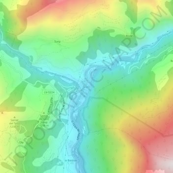
Name: Rialp topographic map, elevation, terrain.
Location: Rialp, Pallars Sobirá, Lérida, Cataluña, 25594, España (42.42300 1.11549 42.46300 1.15549)
Average elevation: 3,491 ft
Minimum elevation: 2,264 ft
Maximum elevation: 5,771 ft
Thank you for supporting this site ❤️
Make a donation
Make a donation
Gear up for your next adventure:
As an Amazon Associate, this site earns from qualifying purchases at no extra cost to you.