Geolocate

Isla Pinta topographic map

Click on the map to display elevation.

Isla Pinta

Pinta Island (Spanish: Isla Pinta), also known as Abingdon Island, after the Earl of Abingdon, is an island located in the Galápagos Islands group, Ecuador. It has an area of 60 km2 (23 sq mi) and a maximum altitude of 777 metres (2,549 ft).

Wikipedia (CC-BY-SA 3.0)

About this map

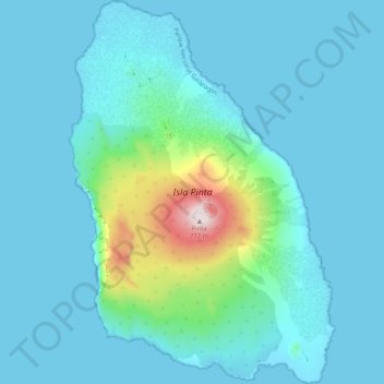
Name: Isla Pinta topographic map, elevation, terrain.

Location: Isla Pinta, Parroquia Santa Rosa, Cantón Santa Cruz, Galápagos, Ecuador (0.53995 -90.79051 0.64365 -90.71842)

Average elevation: 253 ft

Minimum elevation: -7 ft

Maximum elevation: 2,067 ft

Other topographic maps

Click on a map to view its topography, its elevation and its terrain.

Daphne Major

Ecuador > Galápagos > Cantón Santa Cruz

Average elevation: 3 ft

Gear up for your next adventure:

🔭Stargazing Telescopes - Perfect for camping in low-light pollution areas shown on maps
🗺️NatGeo Topo Maps - High-quality waterproof printed topographic maps of US Parks
🛠️Backpacking Tool Kit - Essential toolkit for outdoor repairs
🎒Waterproof Dry Bags - Keep your electronics and maps dry inside your pack
🏔️Mountain Trail Maps - High‑detail maps for popular peaks

As an Amazon Associate, this site earns from qualifying purchases at no extra cost to you.