
Kalenberg topographic map
Click on the map to display elevation.
Kalenberg
Das Dorf liegt westlich von Mechernich. Am Ortsrand verläuft die Bundesstraße 266 von Mechernich zum Kaller Ortsteil Wallenthalerhöhe. Ebenfalls am Ortsrand verläuft die Bahnlinie von Mechernich nach Kall. Direkt an den Ort grenzt die Gemeinde Kall.
About this map
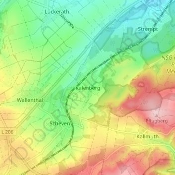
Name: Kalenberg topographic map, elevation, terrain.
Average elevation: 1,234 ft
Minimum elevation: 948 ft
Maximum elevation: 1,634 ft
Other topographic maps
Click on a map to view its topography, its elevation and its terrain.
Angelteiche Feyermühle
Deutschland > Nordrhein-Westfalen > Kreis Euskirchen > Mechernich > Breitenbenden > Burgfey
Average elevation: 1,024 ft
Bescheid
Deutschland > Nordrhein-Westfalen > Kreis Euskirchen > Mechernich > Bleibuir
Average elevation: 1,201 ft