
Farmington topographic map
Click on the map to display elevation.
About this map
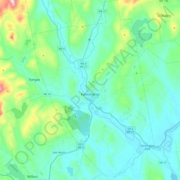
Name: Farmington topographic map, elevation, terrain.
Location: Farmington, Franklin County, Maine, United States (44.58983 -70.22936 44.76036 -70.06578)
Average elevation: 630 ft
Minimum elevation: 305 ft
Maximum elevation: 2,034 ft
Franklin County trails, hiking, mountain biking, running and outdoor activities
Other topographic maps
Click on a map to view its topography, its elevation and its terrain.
Tumbledown Mountain
United States > Maine > Franklin County > Township 6 North of Weld
Average elevation: 2,333 ft
Height of Land
United States > Maine > Franklin County > Township D > Rangeley Plantation
Average elevation: 1,916 ft
Caribou Mountain
United States > Maine > Franklin County > Skinner Township
Average elevation: 2,835 ft
Caribou Mountain
United States > Maine > Franklin County > Skinner Township
Average elevation: 2,835 ft
Mount Abraham
United States > Maine > Franklin County > Mount Abram Township
Average elevation: 3,012 ft