
Thank you for supporting this site ❤️
Make a donation
Make a donation
Gear up for your next adventure:
As an Amazon Associate, this site earns from qualifying purchases at no extra cost to you.
Tiège topographic map
Click on the map to display elevation.
Thank you for supporting this site ❤️
Make a donation
Make a donation
Gear up for your next adventure:
As an Amazon Associate, this site earns from qualifying purchases at no extra cost to you.
About this map
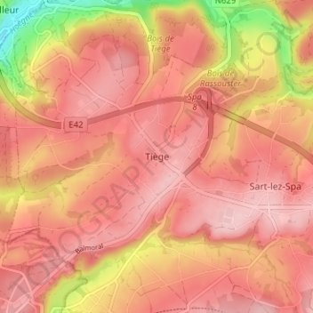
Name: Tiège topographic map, elevation, terrain.
Location: Tiège, Jalhay, Verviers, Luik, Wallonië, 4845, België (50.50125 5.88965 50.54125 5.92965)
Average elevation: 1,102 ft
Minimum elevation: 699 ft
Maximum elevation: 1,266 ft
Thank you for supporting this site ❤️
Make a donation
Make a donation
Gear up for your next adventure:
As an Amazon Associate, this site earns from qualifying purchases at no extra cost to you.