
Thank you for supporting this site ❤️
Make a donation
Make a donation
Gear up for your next adventure:
As an Amazon Associate, this site earns from qualifying purchases at no extra cost to you.
Banal topographic map
Click on the map to display elevation.
Thank you for supporting this site ❤️
Make a donation
Make a donation
Gear up for your next adventure:
As an Amazon Associate, this site earns from qualifying purchases at no extra cost to you.
About this map
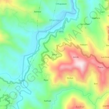
Name: Banal topographic map, elevation, terrain.
Location: Banal, Dharmpur, Mandi, Himachal Pradesh, 175040, India (31.76974 76.73851 31.80974 76.77851)
Average elevation: 2,713 ft
Minimum elevation: 2,047 ft
Maximum elevation: 3,927 ft
Thank you for supporting this site ❤️
Make a donation
Make a donation
Gear up for your next adventure:
As an Amazon Associate, this site earns from qualifying purchases at no extra cost to you.