Geolocate

Ambala topographic map

Click on the map to display elevation.

About this map

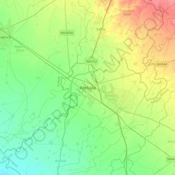
Name: Ambala topographic map, elevation, terrain.

Location: Ambala, Ambala Cantt, Ambala, Haryana, 134002, India (30.22437 76.61042 30.54437 76.93042)

Average elevation: 902 ft

Minimum elevation: 830 ft

Maximum elevation: 1,043 ft

Gear up for your next adventure:

Solar GPS Watches - Advanced multisport watches with built-in topographic maps
📖Nature Tracking Books - Learn to track wildlife and terrain
🛏️Cold Weather Sleeping Bag - Warm sleeping bag for cold conditions
📡Handheld GPS Device - Reliable handheld GPS for outdoor navigation
🧺Microfiber Travel Towels - Compact and fast-drying towels for trail use

As an Amazon Associate, this site earns from qualifying purchases at no extra cost to you.