
São Pedro da Cadeira topographic map
Interactive map
Click on the map to display elevation.
About this map
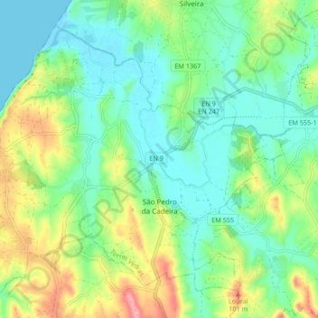
Name: São Pedro da Cadeira topographic map, elevation, terrain.
Location: São Pedro da Cadeira, Torres Vedras, Lisbonne, Portugal (39.05259 -9.42210 39.10693 -9.33889)
Average elevation: 121 ft
Minimum elevation: -3 ft
Maximum elevation: 381 ft
Other topographic maps
Click on a map to view its topography, its elevation and its terrain.
Silveira
Portugal > Lisbonne > Torres Vedras
Silveira, Torres Vedras, Lisbonne, Portugal
Average elevation: 121 ft