
Silveira topographic map
Interactive map
Click on the map to display elevation.
About this map
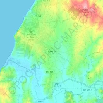
Name: Silveira topographic map, elevation, terrain.
Location: Silveira, Torres Vedras, Lisbonne, Portugal (39.08444 -9.39888 39.13811 -9.31572)
Average elevation: 121 ft
Minimum elevation: -3 ft
Maximum elevation: 440 ft
Other topographic maps
Click on a map to view its topography, its elevation and its terrain.
São Pedro da Cadeira
Portugal > Lisbonne > Torres Vedras
São Pedro da Cadeira, Torres Vedras, Lisbonne, Portugal
Average elevation: 121 ft