
Izabal topographic map
Interactive map
Click on the map to display elevation.
About this map
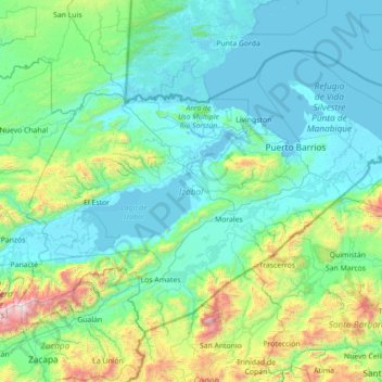
Name: Izabal topographic map, elevation, terrain.
Location: Izabal, Guatemala (15.06828 -89.62686 16.06996 -88.17558)
Average elevation: 971 ft
Minimum elevation: -7 ft
Maximum elevation: 8,799 ft
Other topographic maps
Click on a map to view its topography, its elevation and its terrain.
Chiriqui
Guatemala > Izabal > Los Amates
Chiriqui, Los Amates, Izabal, Guatemala
Average elevation: 167 ft
Puerto Barrios
Guatemala > Izabal > Puerto Barrios
Puerto Barrios, Izabal, Guatemala
Average elevation: 256 ft
Lake Izabal
Lake Izabal, El Estor, Izabal, Guatemala
Average elevation: 604 ft