
Make a donation
Gear up for your next adventure:
As an Amazon Associate, this site earns from qualifying purchases at no extra cost to you.
Puerto Barrios topographic map
Click on the map to display elevation.
Make a donation
Gear up for your next adventure:
As an Amazon Associate, this site earns from qualifying purchases at no extra cost to you.
Puerto Barrios
The municipality's elevation varies from level at Punta de Manabique to 1276 m above sea level at Cerro San Gil. The municipal capital is located on the shore of Santo Tomás internal bay, which is part of Amatique Bay. There is a small peninsula called Punta de Manabique which separates the small bay from the Gulf of Honduras, and shelters it from storms.
Make a donation
Gear up for your next adventure:
As an Amazon Associate, this site earns from qualifying purchases at no extra cost to you.
About this map
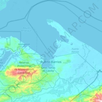
Name: Puerto Barrios topographic map, elevation, terrain.
Location: Puerto Barrios, Izabal, Guatemala (15.50177 -88.74738 16.07236 -88.21344)
Average elevation: 256 ft
Minimum elevation: -13 ft
Maximum elevation: 5,010 ft
Make a donation
Gear up for your next adventure:
As an Amazon Associate, this site earns from qualifying purchases at no extra cost to you.