Geolocate

Crete topographic map

Click on the map to display elevation.

About this map

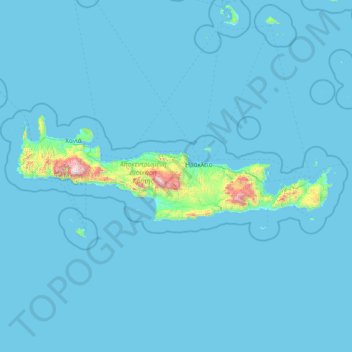
Name: Crete topographic map, elevation, terrain.

Location: Crete, Greece (34.70061 23.35135 35.79466 26.47587)

Average elevation: 164 ft

Minimum elevation: 0 ft

Maximum elevation: 8,005 ft

Gear up for your next adventure:

GPS Sports Watch - GPS watch for running, hiking and training
🧭GPS Watch Accessories - Bands and chargers for GPS watches
🪑Ultralight Camp Chairs - Portable seating for resting after a long day of mapping
🦶Carbon Trekking Poles - Reduce knee impact on steep descents with ultra-light poles
🖼️Topo Map Wall Art - Decorative topographic prints of famous peaks and regions

As an Amazon Associate, this site earns from qualifying purchases at no extra cost to you.