
Marble topographic map
Click on the map to display elevation.
About this map
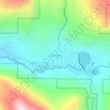
Name: Marble topographic map, elevation, terrain.
Location: Marble, Gunnison County, Colorado, United States (39.06769 -107.19962 39.07676 -107.18179)
Average elevation: 8,566 ft
Minimum elevation: 7,844 ft
Maximum elevation: 10,240 ft
Gunnison County trails, hiking, mountain biking, running and outdoor activities
Other topographic maps
Click on a map to view its topography, its elevation and its terrain.
Gunnison
United States > Colorado > Gunnison County
Also in 1880, the cattle industry in Gunnison was established. Realizing the poor conditions for farming (with only about eleven inches of rainfall annually and the short growing season due to the high elevation and alpine environment) the local farmers turned to ranching and began breeding cattle. To do this…
Average elevation: 7,772 ft