Geolocate

Castelletta topographic map

Click on the map to display elevation.

About this map

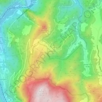
Name: Castelletta topographic map, elevation, terrain.

Location: Castelletta, Fabriano, Ancona, Marche, Italia (43.38260 12.98760 43.42260 13.02760)

Average elevation: 1,686 ft

Minimum elevation: 568 ft

Maximum elevation: 3,465 ft

Gear up for your next adventure:

🪵Folding Camp Saw - Compact saw for wood and campsite work
🎒Day Hiking Backpack - Lightweight backpack perfect for day trips and outdoor adventures
📷Action Cameras - Rugged cameras to document your journeys across rugged terrain
🚪Portable Camp Chair - Foldable chair for comfort at camp
❄️Traction Cleats - Prevent slips on icy trails during winter hikes

As an Amazon Associate, this site earns from qualifying purchases at no extra cost to you.