
Thank you for supporting this site ❤️
Make a donation
Make a donation
Gear up for your next adventure:
As an Amazon Associate, this site earns from qualifying purchases at no extra cost to you.
Vantage topographic map
Click on the map to display elevation.
Thank you for supporting this site ❤️
Make a donation
Make a donation
Gear up for your next adventure:
As an Amazon Associate, this site earns from qualifying purchases at no extra cost to you.
About this map
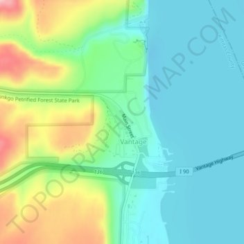
Name: Vantage topographic map, elevation, terrain.
Location: Vantage, Kittitas County, Washington, United States (46.94099 -120.00120 46.95078 -119.98303)
Average elevation: 715 ft
Minimum elevation: 548 ft
Maximum elevation: 1,129 ft
Thank you for supporting this site ❤️
Make a donation
Make a donation
Gear up for your next adventure:
As an Amazon Associate, this site earns from qualifying purchases at no extra cost to you.
Other topographic maps
Click on a map to view its topography, its elevation and its terrain.
Ellensburg
United States > Washington > Kittitas County > Ellensburg > Ellensburg
Average elevation: 1,591 ft