
Make a donation
Gear up for your next adventure:
As an Amazon Associate, this site earns from qualifying purchases at no extra cost to you.
Sky Londa topographic map
Click on the map to display elevation.
Make a donation
Gear up for your next adventure:
As an Amazon Associate, this site earns from qualifying purchases at no extra cost to you.
Sky Londa
Atop the coastal range west of Woodside, the community's official elevation is 1,520 feet (463 m) above mean sea level (AMSL).
Make a donation
Gear up for your next adventure:
As an Amazon Associate, this site earns from qualifying purchases at no extra cost to you.
About this map
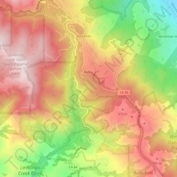
Name: Sky Londa topographic map, elevation, terrain.
Average elevation: 1,437 ft
Minimum elevation: 367 ft
Maximum elevation: 2,205 ft
San Mateo County trails, hiking, mountain biking, running and outdoor activities
Make a donation
Gear up for your next adventure:
As an Amazon Associate, this site earns from qualifying purchases at no extra cost to you.
Other topographic maps
Click on a map to view its topography, its elevation and its terrain.
Make a donation
Gear up for your next adventure:
As an Amazon Associate, this site earns from qualifying purchases at no extra cost to you.
Highlands
United States > California > San Mateo County > San Mateo Highlands
Average elevation: 423 ft
Make a donation
Gear up for your next adventure:
As an Amazon Associate, this site earns from qualifying purchases at no extra cost to you.
Upper Crystal Springs Reservoir
United States > California > San Mateo County
Average elevation: 394 ft
Pacifica
United States > California > San Mateo County > Pacifica > Pacifica
Average elevation: 305 ft
Make a donation
Gear up for your next adventure:
As an Amazon Associate, this site earns from qualifying purchases at no extra cost to you.
San Carlos
United States > California > San Mateo County > San Carlos > San Carlos
Average elevation: 154 ft
Burlingame
United States > California > San Mateo County > Burlingame > Burlingame
Average elevation: 184 ft
Make a donation
Gear up for your next adventure:
As an Amazon Associate, this site earns from qualifying purchases at no extra cost to you.
Pillar Point Harbor
United States > California > San Mateo County > El Granada
Average elevation: 43 ft
Half Moon Bay
United States > California > San Mateo County > Half Moon Bay > Half Moon Bay
Average elevation: 240 ft
Coyote Point Recreation Area
United States > California > San Mateo County > San Mateo
Average elevation: 3 ft
Westborough
United States > California > San Mateo County > South San Francisco
Average elevation: 394 ft
Make a donation
Gear up for your next adventure:
As an Amazon Associate, this site earns from qualifying purchases at no extra cost to you.