
Palmyra topographic map
Interactive map
Click on the map to display elevation.
About this map
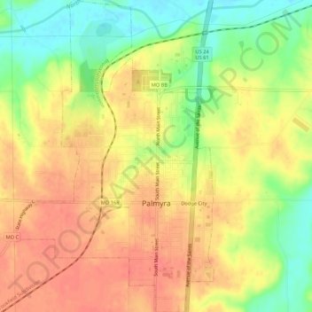
Name: Palmyra topographic map, elevation, terrain.
Location: Palmyra, Marion County, Missouri, United States (39.77991 -91.54739 39.82080 -91.51342)
Average elevation: 600 ft
Minimum elevation: 479 ft
Maximum elevation: 686 ft
Other topographic maps
Click on a map to view its topography, its elevation and its terrain.
Hannibal
United States > Missouri > Marion County
Hannibal, Marion County, Missouri, 63401, United States
Average elevation: 558 ft