Geolocate

Nowon-gu topographic map

Click on the map to display elevation.

About this map

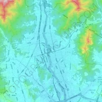
Name: Nowon-gu topographic map, elevation, terrain.

Location: Nowon-gu, Seoul, South Korea (37.61431 127.04172 37.69622 127.11249)

Average elevation: 325 ft

Minimum elevation: 36 ft

Maximum elevation: 2,178 ft

Other topographic maps

Click on a map to view its topography, its elevation and its terrain.

Susong-dong

South Korea > Seoul > Susong-dong

Average elevation: 223 ft

Gye-dong

South Korea > Seoul

Average elevation: 249 ft

Inwangsan (Mt.)

South Korea > Seoul

Average elevation: 371 ft

Gear up for your next adventure:

🕶️Glacier Sunglasses - Side shields to protect eyes from high-altitude snow glare
🪶Camping Sleeping Pad - Comfortable sleeping pad for backpacking
🩳Quick‑Dry Hiking Shorts - Comfortable and quick‑dry shorts for summer hiking
🗃️Trail First Aid Kit - Essential kit for outdoor injuries and emergencies
🚗GPS Dash Cams - Record your scenic drives through mountain passes and canyons

As an Amazon Associate, this site earns from qualifying purchases at no extra cost to you.