
Thank you for supporting this site ❤️
Make a donation
Make a donation
Gear up for your next adventure:
As an Amazon Associate, this site earns from qualifying purchases at no extra cost to you.
Jardín topographic map
Click on the map to display elevation.
Thank you for supporting this site ❤️
Make a donation
Make a donation
Gear up for your next adventure:
As an Amazon Associate, this site earns from qualifying purchases at no extra cost to you.
About this map
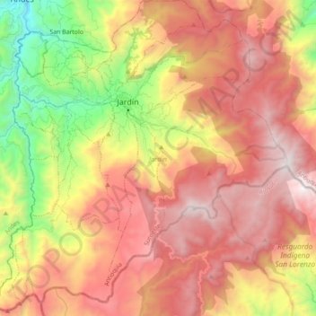
Name: Jardín topographic map, elevation, terrain.
Location: Jardín, Suroeste, Antioquia, 056050, Colombia (5.48039 -75.90587 5.65474 -75.73071)
Average elevation: 7,720 ft
Minimum elevation: 4,131 ft
Maximum elevation: 10,666 ft
Thank you for supporting this site ❤️
Make a donation
Make a donation
Gear up for your next adventure:
As an Amazon Associate, this site earns from qualifying purchases at no extra cost to you.