Geolocate

Weaver topographic map

Click on the map to display elevation.

About this map

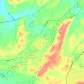
Name: Weaver topographic map, elevation, terrain.

Location: Weaver, Calhoun County, Alabama, 36277, United States (33.74192 -85.83489 33.78285 -85.77600)

Average elevation: 709 ft

Minimum elevation: 571 ft

Maximum elevation: 866 ft

Calhoun County trails, hiking, mountain biking, running and outdoor activities

Other topographic maps

Click on a map to view its topography, its elevation and its terrain.

Coldwater

United States > Alabama > Calhoun County > Oxford

Average elevation: 633 ft

Golden Springs

United States > Alabama > Calhoun County > Anniston

Average elevation: 948 ft

Bonny Brook

United States > Alabama > Calhoun County > Jacksonville

Average elevation: 781 ft

McKibben

United States > Alabama > Calhoun County > Oxford

Average elevation: 794 ft

Alexandria

United States > Alabama > Calhoun County

Average elevation: 617 ft

Blue Mountain

United States > Alabama > Calhoun County > Anniston

Average elevation: 968 ft

Gear up for your next adventure:

📦Dry Bags Set - Waterproof storage for electronics and clothes
🛡️Bear Spray Outdoor - Protection in bear country hikes
🔪Outdoor Multitools - Essential survival tools for gear repair and field use
📚USA Hiking Guide Books - Top trail guides and map books
🎒Day Hiking Backpack - Lightweight backpack perfect for day trips and outdoor adventures

As an Amazon Associate, this site earns from qualifying purchases at no extra cost to you.