
Thank you for supporting this site ❤️
Make a donation
Make a donation
Gear up for your next adventure:
As an Amazon Associate, this site earns from qualifying purchases at no extra cost to you.
Vollmarshausen topographic map
Click on the map to display elevation.
Thank you for supporting this site ❤️
Make a donation
Make a donation
Gear up for your next adventure:
As an Amazon Associate, this site earns from qualifying purchases at no extra cost to you.
About this map
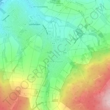
Name: Vollmarshausen topographic map, elevation, terrain.
Location: Vollmarshausen, Lohfelden, Landkreis Kassel, Hessen, Deutschland (51.24466 9.54522 51.28017 9.59813)
Average elevation: 823 ft
Minimum elevation: 541 ft
Maximum elevation: 1,296 ft
Thank you for supporting this site ❤️
Make a donation
Make a donation
Gear up for your next adventure:
As an Amazon Associate, this site earns from qualifying purchases at no extra cost to you.
Other topographic maps
Click on a map to view its topography, its elevation and its terrain.
Am Hammelsberg
Deutschland > Hessen > Landkreis Kassel > Lohfelden > Ochshausen
Average elevation: 650 ft