
Thank you for supporting this site ❤️
Make a donation
Make a donation
Gear up for your next adventure:
As an Amazon Associate, this site earns from qualifying purchases at no extra cost to you.
Bahati topographic map
Click on the map to display elevation.
Thank you for supporting this site ❤️
Make a donation
Make a donation
Gear up for your next adventure:
As an Amazon Associate, this site earns from qualifying purchases at no extra cost to you.
About this map
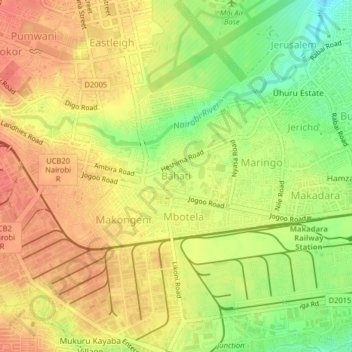
Name: Bahati topographic map, elevation, terrain.
Location: Bahati, Nairobi, Nairobi County, 00101, Kenya (-1.31305 36.83600 -1.27305 36.87600)
Average elevation: 5,374 ft
Minimum elevation: 5,262 ft
Maximum elevation: 5,446 ft
Thank you for supporting this site ❤️
Make a donation
Make a donation
Gear up for your next adventure:
As an Amazon Associate, this site earns from qualifying purchases at no extra cost to you.