Geolocate

Turville topographic map

Click on the map to display elevation.

👉 Easily get elevation data in JSON, GeoTIFF and KML formats using Elevation API
Thank you for supporting this site ❤️
Make a donation

About this map

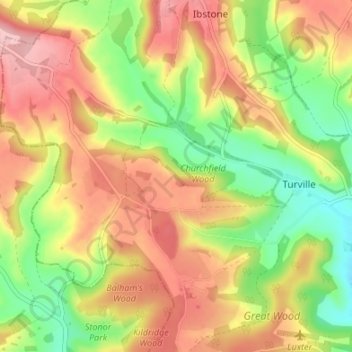
Name: Turville topographic map, elevation, terrain.

Location: Turville, Buckinghamshire, England, United Kingdom (51.59388 -0.95014 51.63565 -0.88792)

Average elevation: 495 ft

Minimum elevation: 226 ft

Maximum elevation: 748 ft

Other topographic maps

Click on a map to view its topography, its elevation and its terrain.

Bledlow Ridge

United Kingdom > England > Buckinghamshire

Average elevation: 525 ft

Loudwater

United Kingdom > England > Buckinghamshire

Average elevation: 299 ft

Grove

United Kingdom > England > Buckinghamshire

Average elevation: 308 ft

Burcott

United Kingdom > England > Buckinghamshire > Wing

Average elevation: 407 ft

Tylers Green

United Kingdom > England > Buckinghamshire

Average elevation: 492 ft

Haddington Hill

United Kingdom > England > Buckinghamshire > Halton

Average elevation: 682 ft

Gear up for your next adventure:

🎁Geography Themed Gifts - Unique gift ideas for map lovers and geography enthusiasts
📶Satellite Messenger - Communication device off‑grid
🔦Powerful Headlamps - Ultra-bright hands-free lighting for night navigation
🧯Portable Fire Pit - Compact fire pit for camping spots
🥄Camping Utensil Set - Lightweight utensils for outdoor meals

As an Amazon Associate, this site earns from qualifying purchases at no extra cost to you.