Geolocate

Nowthen topographic map

Click on the map to display elevation.

About this map

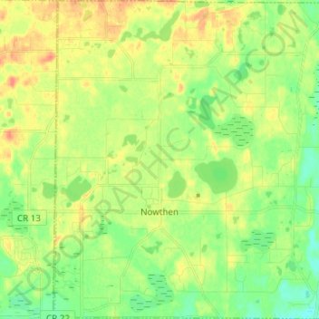
Name: Nowthen topographic map, elevation, terrain.

Location: Nowthen, Anoka County, Minnesota, United States (45.29889 -93.51099 45.38552 -93.38839)

Average elevation: 932 ft

Minimum elevation: 869 ft

Maximum elevation: 1,001 ft

Anoka County trails, hiking, mountain biking, running and outdoor activities

Other topographic maps

Click on a map to view its topography, its elevation and its terrain.

Filmore Park

United States > Minnesota > Anoka County > Blaine

Average elevation: 906 ft

Linwood

United States > Minnesota > Anoka County

Average elevation: 909 ft

Johnsville

United States > Minnesota > Anoka County > Blaine

Average elevation: 902 ft

Martin Lake

United States > Minnesota > Anoka County

Average elevation: 906 ft

Cedar

United States > Minnesota > Anoka County > Oak Grove

Average elevation: 899 ft

Island Lake

United States > Minnesota > Anoka County > Linwood

Average elevation: 909 ft

Gear up for your next adventure:

🚪Portable Camp Chair - Foldable chair for comfort at camp
🌡️Handheld Weather Meters - Measure wind, temp, and pressure for safe mountain travel
🏕️Family Camping Gear - Essentials for group camping trips
🗺️NatGeo Topo Maps - High-quality waterproof printed topographic maps of US Parks
🥩Freeze-Dried Meals - Nutritious and lightweight food for remote expeditions

As an Amazon Associate, this site earns from qualifying purchases at no extra cost to you.