
Thank you for supporting this site ❤️
Make a donation
Make a donation
Gear up for your next adventure:
As an Amazon Associate, this site earns from qualifying purchases at no extra cost to you.
Avelino topographic map
Click on the map to display elevation.
Thank you for supporting this site ❤️
Make a donation
Make a donation
Gear up for your next adventure:
As an Amazon Associate, this site earns from qualifying purchases at no extra cost to you.
About this map
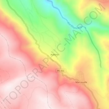
Name: Avelino topographic map, elevation, terrain.
Location: Avelino, Pucará, Huancayo, Junín, Peru (-12.23529 -75.13623 -12.19529 -75.09623)
Average elevation: 12,680 ft
Minimum elevation: 11,260 ft
Maximum elevation: 13,570 ft
Thank you for supporting this site ❤️
Make a donation
Make a donation
Gear up for your next adventure:
As an Amazon Associate, this site earns from qualifying purchases at no extra cost to you.