
Make a donation
Gear up for your next adventure:
As an Amazon Associate, this site earns from qualifying purchases at no extra cost to you.
Cortenbergh topographic map
Click on the map to display elevation.
Make a donation
Gear up for your next adventure:
As an Amazon Associate, this site earns from qualifying purchases at no extra cost to you.
About this map
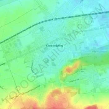
Name: Cortenbergh topographic map, elevation, terrain.
Average elevation: 177 ft
Minimum elevation: 118 ft
Maximum elevation: 292 ft
Make a donation
Gear up for your next adventure:
As an Amazon Associate, this site earns from qualifying purchases at no extra cost to you.
Other topographic maps
Click on a map to view its topography, its elevation and its terrain.
Moorsel
Belgique > Brabant flamand > Louvain > Tervuren
Ce village, entouré de Vossem, Sterrebeek, Kortenberg, Leefdaal et Tervuren, est situé sur le plateau brabançon ondoyant entre 85 et 90 m d'altitude. Ce hameau résidentiel combine à la fois un caractère rural et périurbain ce qui se caractérise par une alternance de champs, de villas et de vieilles…
Average elevation: 246 ft
Make a donation
Gear up for your next adventure:
As an Amazon Associate, this site earns from qualifying purchases at no extra cost to you.