
Prudhoe Bay topographic map
Interactive map
Click on the map to display elevation.
About this map
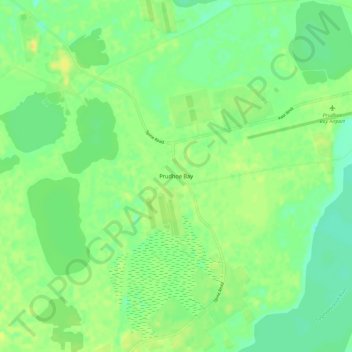
Name: Prudhoe Bay topographic map, elevation, terrain.
Location: Prudhoe Bay, North Slope, Alaska, 99734, United States (70.22501 -148.41784 70.26501 -148.37784)
Average elevation: 33 ft
Minimum elevation: 0 ft
Maximum elevation: 66 ft
Other topographic maps
Click on a map to view its topography, its elevation and its terrain.
Wainwright
United States > Alaska > North Slope
Wainwright, North Slope, Alaska, 99782, United States
Average elevation: 16 ft
Howe Island
United States > Alaska > North Slope
Howe Island, North Slope, Alaska, United States
Average elevation: 0 ft
Deadhorse
United States > Alaska > North Slope
Deadhorse, North Slope, Alaska, United States
Average elevation: 49 ft
Igloo Mountain
United States > Alaska > North Slope
Igloo Mountain, North Slope, Alaska, United States
Average elevation: 1,942 ft
Utqiaġvik
United States > Alaska > North Slope
Utqiaġvik, North Slope, Alaska, 99273, United States
Average elevation: 13 ft