
东吴镇 topographic map
Interactive map
Click on the map to display elevation.
About this map
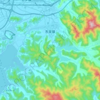
Name: 东吴镇 topographic map, elevation, terrain.
Location: 东吴镇, 鄞州区, 宁波市, 浙江省, 中国 (29.74126 121.68766 29.83593 121.82151)
Average elevation: 354 ft
Minimum elevation: 0 ft
Maximum elevation: 2,126 ft
Other topographic maps
Click on a map to view its topography, its elevation and its terrain.