
Make a donation
Gear up for your next adventure:
As an Amazon Associate, this site earns from qualifying purchases at no extra cost to you.
Municipio de Escuintla topographic map
Click on the map to display elevation.
Make a donation
Gear up for your next adventure:
As an Amazon Associate, this site earns from qualifying purchases at no extra cost to you.
About this map
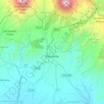
Name: Municipio de Escuintla topographic map, elevation, terrain.
Location: Municipio de Escuintla, Escuintla, 05001, Guatemala (14.15538 -90.96124 14.47462 -90.66720)
Average elevation: 2,175 ft
Minimum elevation: 164 ft
Maximum elevation: 12,333 ft
Make a donation
Gear up for your next adventure:
As an Amazon Associate, this site earns from qualifying purchases at no extra cost to you.
Other topographic maps
Click on a map to view its topography, its elevation and its terrain.
Pacaya
Guatemala > Escuintla > San Vicente Pacaya > San Vicente Pacaya > El Cedro
Average elevation: 6,804 ft
Make a donation
Gear up for your next adventure:
As an Amazon Associate, this site earns from qualifying purchases at no extra cost to you.