
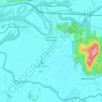
Streda nad Bodrogom topographic map
Interactive map
Click on the map to display elevation.
About this map
Name: Streda nad Bodrogom topographic map, elevation, terrain.
Average elevation: 348 ft
Minimum elevation: 289 ft
Maximum elevation: 892 ft
The village has the lowest altitude (94 metres (308 ft) above sea level) in Slovakia.
Other topographic maps
Click on a map to view its topography, its elevation and its terrain.
Bačka
Slovakia > Region of Košice > District of Trebišov
Bačka, District of Trebišov, Region of Košice, Eastern Slovakia, Slovakia
Average elevation: 331 ft
Bara
Slovakia > Region of Košice > District of Trebišov
Bara, District of Trebišov, Region of Košice, Eastern Slovakia, Slovakia
Average elevation: 525 ft
Boťany
Slovakia > Region of Košice > District of Trebišov
Boťany, District of Trebišov, Region of Košice, Eastern Slovakia, 076 43, Slovakia
Average elevation: 331 ft