Geolocate

Bara topographic map

Click on the map to display elevation.

Bara

The village lies at an altitude of 181 metres and covers an area of 6.252 km². It has a population of 350 people.

Wikipedia (CC-BY-SA 3.0)

About this map

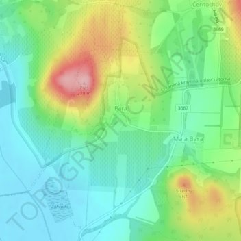
Name: Bara topographic map, elevation, terrain.

Location: Bara, District of Trebišov, Region of Košice, Eastern Slovakia, Slovakia (48.40896 21.70662 48.43916 21.74904)

Average elevation: 525 ft

Minimum elevation: 354 ft

Maximum elevation: 876 ft

Gear up for your next adventure:

🦺Reflective Outdoor Gear - Safety gear for low‑light conditions
👖Convertible Hiking Pants - Versatile zip-off pants for changing altitudes and temperatures
🚁Photography Drones - Capture stunning aerial views of landforms and topography
🌐World Map Poster - Decorative world maps with topographic info
🧤Hiking Gloves - Protective gloves for rugged trails

As an Amazon Associate, this site earns from qualifying purchases at no extra cost to you.