
Make a donation
Gear up for your next adventure:
As an Amazon Associate, this site earns from qualifying purchases at no extra cost to you.
Cholet topographic map
Click on the map to display elevation.
Make a donation
Gear up for your next adventure:
As an Amazon Associate, this site earns from qualifying purchases at no extra cost to you.
About this map
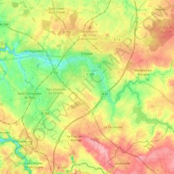
Name: Cholet topographic map, elevation, terrain.
Average elevation: 390 ft
Minimum elevation: 187 ft
Maximum elevation: 607 ft
Make a donation
Gear up for your next adventure:
As an Amazon Associate, this site earns from qualifying purchases at no extra cost to you.
Other topographic maps
Click on a map to view its topography, its elevation and its terrain.
Le Moulin Géant
France > Pays de la Loire > Maine-et-Loire > Rochefort-sur-Loire
Average elevation: 151 ft
La Roche Abilen
France > Pays de la Loire > Maine-et-Loire > Les Bois d'Anjou
Average elevation: 125 ft
Make a donation
Gear up for your next adventure:
As an Amazon Associate, this site earns from qualifying purchases at no extra cost to you.