Geolocate

Morjim topographic map

Click on the map to display elevation.

About this map

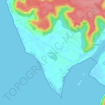
Name: Morjim topographic map, elevation, terrain.

Location: Morjim, Pernem, North Goa, Goa, 403512, India (15.61030 73.71370 15.65030 73.75370)

Average elevation: 59 ft

Minimum elevation: -3 ft

Maximum elevation: 299 ft

Other topographic maps

Click on a map to view its topography, its elevation and its terrain.

Morjim Beach

India > Goa > Pernem

Average elevation: 10 ft

Arambol Sweet Water Lake

India > Goa > Pernem > Arambol

Average elevation: 82 ft

Gear up for your next adventure:

🥾Men's Hiking Boots - Durable, waterproof footwear for rugged terrain and steep inclines
📚Navigation Handbooks - Master the art of reading topographic maps and using a compass
🌧️Backpack Rain Cover - Keep gear dry in wet weather
🔊Portable Camp Speaker - Music and alerts at camp
🪑Portable Camp Table - Compact table for campsite meals

As an Amazon Associate, this site earns from qualifying purchases at no extra cost to you.