
Make a donation
Gear up for your next adventure:
As an Amazon Associate, this site earns from qualifying purchases at no extra cost to you.
Kilkenny topographic map
Click on the map to display elevation.
Make a donation
Gear up for your next adventure:
As an Amazon Associate, this site earns from qualifying purchases at no extra cost to you.
Kilkenny
Kilkenny is situated in the Nore Valley on both banks of the River Nore, at the centre of County Kilkenny in the province of Leinster in the south-east of Ireland. It is 117 kilometres (73 mi) away the capital Dublin and 48 kilometres (30 mi) north from the nearest city Waterford. Wexford is 80 kilometres (50 mi) to the south-east and Limerick is 122 kilometres (76 mi) to the west. The elevation is 60 metres (200 ft) above mean sea level. The area of Kilkenny borough is 3.74 square kilometres (1.44 sq mi). The first edition of the Ordnance Survey map for Kilkenny was in 1837 and is held by the County Library.
Make a donation
Gear up for your next adventure:
As an Amazon Associate, this site earns from qualifying purchases at no extra cost to you.
About this map
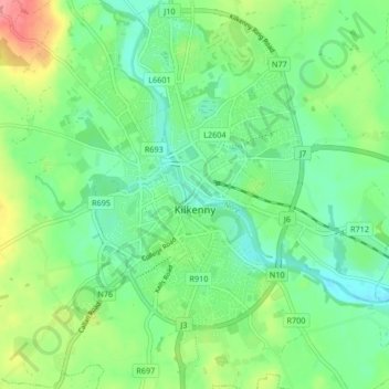
Name: Kilkenny topographic map, elevation, terrain.
Location: Kilkenny, County Kilkenny, Leinster, Ireland (52.62761 -7.28545 52.67819 -7.20616)
Average elevation: 203 ft
Minimum elevation: 118 ft
Maximum elevation: 374 ft
Make a donation
Gear up for your next adventure:
As an Amazon Associate, this site earns from qualifying purchases at no extra cost to you.
Other topographic maps
Click on a map to view its topography, its elevation and its terrain.
Brandon Hill
Brandon Hill (Irish: Cnoc Bhréanail) is the highest mountain in County Kilkenny, Ireland, with an elevation of 515 m (1,690 ft) and prominence at 448 m (1,470 ft). The South Leinster Way, a long-distance trail, meandering through the Barrow Valley and traverses Brandon Hill. The village of Graiguenamanagh and…
Average elevation: 965 ft
Make a donation
Gear up for your next adventure:
As an Amazon Associate, this site earns from qualifying purchases at no extra cost to you.
Make a donation
Gear up for your next adventure:
As an Amazon Associate, this site earns from qualifying purchases at no extra cost to you.
Make a donation
Gear up for your next adventure:
As an Amazon Associate, this site earns from qualifying purchases at no extra cost to you.
Brandon Hill
Brandon Hill (Irish: Cnoc Bhréanail) is the highest mountain in County Kilkenny, Ireland, with an elevation of 515 m (1,690 ft) and prominence at 448 m (1,470 ft). The South Leinster Way, a long-distance trail, meandering through the Barrow Valley and traverses Brandon Hill. The village of Graiguenamanagh and…
Average elevation: 965 ft