Geolocate

Rivington topographic map

Click on the map to display elevation.

About this map

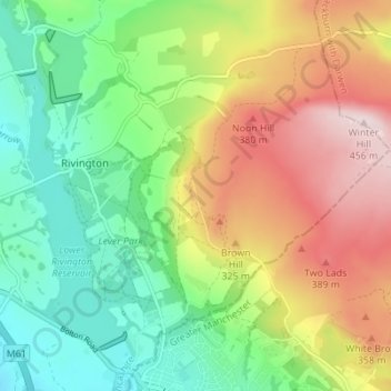
Name: Rivington topographic map, elevation, terrain.

Location: Rivington, Chorley, Lancashire, England, United Kingdom (53.60165 -2.57631 53.64257 -2.51133)

Average elevation: 801 ft

Minimum elevation: 328 ft

Maximum elevation: 1,496 ft

Other topographic maps

Click on a map to view its topography, its elevation and its terrain.

Rivington Pike

United Kingdom > England > Lancashire > Chorley > Rivington

Average elevation: 886 ft

Gear up for your next adventure:

🔥Plasma Lighters - Windproof lighters that work in any weather condition
🔋Rechargeable Batteries - Power up your outdoor devices
🧭Hiking Compass - Precision compass for reliable navigation in the wilderness
🛠️Backpacking Tool Kit - Essential toolkit for outdoor repairs
🪶LED Camping Lantern - Bright lantern for camp lighting

As an Amazon Associate, this site earns from qualifying purchases at no extra cost to you.