Geolocate

Brooklyn topographic map

Click on the map to display elevation.

About this map

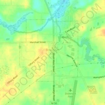
Name: Brooklyn topographic map, elevation, terrain.

Location: Brooklyn, Jackson County, Michigan, United States (42.09663 -84.25982 42.11368 -84.23946)

Average elevation: 984 ft

Minimum elevation: 928 ft

Maximum elevation: 1,030 ft

Jackson County trails, hiking, mountain biking, running and outdoor activities

Other topographic maps

Click on a map to view its topography, its elevation and its terrain.

Liberty

United States > Michigan > Jackson County

Average elevation: 1,024 ft

White Lake

United States > Michigan > Jackson County

Average elevation: 945 ft

Sherman Lake

United States > Michigan > Jackson County

Average elevation: 968 ft

Gear up for your next adventure:

🪶Camp Gear Gift Set - Perfect gift bundle for outdoor fans
💧Water Filtration Bottles - Safely drink from streams and lakes while exploring
🎒Trail Energy Bars - High‑calorie bars for hiking energy
🧭Pro Hiking Compasses - High-accuracy liquid-filled compasses for topographic orientation
Backpacking Tents - Weight-optimized shelters for multi-day topographic surveys

As an Amazon Associate, this site earns from qualifying purchases at no extra cost to you.