
Make a donation
Gear up for your next adventure:
As an Amazon Associate, this site earns from qualifying purchases at no extra cost to you.
Muffendorf topographic map
Click on the map to display elevation.
Make a donation
Gear up for your next adventure:
As an Amazon Associate, this site earns from qualifying purchases at no extra cost to you.
Muffendorf
Muffendorf liegt an einem Berghang zwischen dem höher gelegenen Heiderhof und Pennenfeld im Rheintal. Im Norden wird es von Alt-Godesberg und im Süden von Lannesdorf begrenzt.
Make a donation
Gear up for your next adventure:
As an Amazon Associate, this site earns from qualifying purchases at no extra cost to you.
About this map
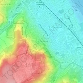
Name: Muffendorf topographic map, elevation, terrain.
Average elevation: 338 ft
Minimum elevation: 177 ft
Maximum elevation: 620 ft
Make a donation
Gear up for your next adventure:
As an Amazon Associate, this site earns from qualifying purchases at no extra cost to you.
Other topographic maps
Click on a map to view its topography, its elevation and its terrain.
Bonn
Deutschland > Nordrhein-Westfalen > Bonn
Bonn hat seinen geografischen Mittelpunkt am Bundeskanzlerplatz, der sich im Ortsteil Gronau befindet. Die geografische Lage des Platzes ist 50° 43′ 8,8″ N, 7° 7′ 3,3″ O50.7191138888897.1175722222222. Die Bonner Innenstadt, die nicht zum Rhein hin ausgerichtet ist, liegt auf einer Höhe von 56 m bis 61 m ü. NHN.
Average elevation: 453 ft
Make a donation
Gear up for your next adventure:
As an Amazon Associate, this site earns from qualifying purchases at no extra cost to you.
Oberholtorf
Deutschland > Nordrhein-Westfalen > Bonn > Holtorf > Oberholtorf
Average elevation: 443 ft