
Erie topographic map
Click on the map to display elevation.
About this map
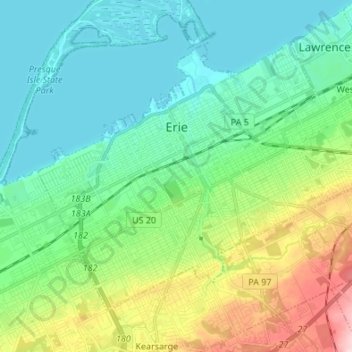
Name: Erie topographic map, elevation, terrain.
Location: Erie, Erie County, Pennsylvania, United States (42.07726 -80.13867 42.15365 -80.00351)
Average elevation: 751 ft
Minimum elevation: 558 ft
Maximum elevation: 1,296 ft
Erie County trails, hiking, mountain biking, running and outdoor activities
Other topographic maps
Click on a map to view its topography, its elevation and its terrain.
East Springfield
United States > Pennsylvania > Erie County > Springfield Township
Average elevation: 751 ft
Reeds Corners
United States > Pennsylvania > Erie County > McKean Township
Average elevation: 1,352 ft
North Springfield
United States > Pennsylvania > Erie County > Springfield Township
Average elevation: 653 ft