
Make a donation
Gear up for your next adventure:
As an Amazon Associate, this site earns from qualifying purchases at no extra cost to you.
Flensburg topographic map
Click on the map to display elevation.
Make a donation
Gear up for your next adventure:
As an Amazon Associate, this site earns from qualifying purchases at no extra cost to you.
About this map
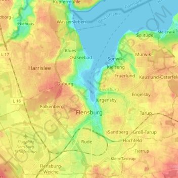
Name: Flensburg topographic map, elevation, terrain.
Location: Flensburg, Schleswig-Holstein, Germany (54.75180 9.35730 54.83707 9.50681)
Average elevation: 115 ft
Minimum elevation: -7 ft
Maximum elevation: 240 ft
Make a donation
Gear up for your next adventure:
As an Amazon Associate, this site earns from qualifying purchases at no extra cost to you.
Other topographic maps
Click on a map to view its topography, its elevation and its terrain.
Hundestrand Brasilien
Germany > Schleswig-Holstein > Plön > Schönberg (Holstein) > Schönberger Strand > Brasilien
Average elevation: 0 ft
Langballigau
Germany > Schleswig-Holstein > Schleswig-Flensburg > Langballigholz
Average elevation: 39 ft
Make a donation
Gear up for your next adventure:
As an Amazon Associate, this site earns from qualifying purchases at no extra cost to you.
Schleswig
Germany > Schleswig-Holstein > Schleswig-Flensburg > Schleswig > Schleswig
Average elevation: 79 ft