
Make a donation
Gear up for your next adventure:
As an Amazon Associate, this site earns from qualifying purchases at no extra cost to you.
Baardegem topographic map
Click on the map to display elevation.
Make a donation
Gear up for your next adventure:
As an Amazon Associate, this site earns from qualifying purchases at no extra cost to you.
Baardegem
Baardegem ligt in Zandlemig Vlaanderen op een hoogte van 25-47 meter. Het hoogste punt is de Helderenberg. Naar het zuiden toe begint een heuvelachtig landschap. In het zuiden vindt men het Kravaalbos.
Make a donation
Gear up for your next adventure:
As an Amazon Associate, this site earns from qualifying purchases at no extra cost to you.
About this map
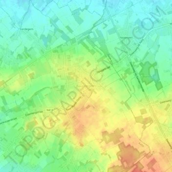
Name: Baardegem topographic map, elevation, terrain.
Location: Baardegem, Aalst, Oost-Vlaanderen, Vlaanderen, België (50.93892 4.12025 50.97272 4.16343)
Average elevation: 112 ft
Minimum elevation: 43 ft
Maximum elevation: 194 ft
Make a donation
Gear up for your next adventure:
As an Amazon Associate, this site earns from qualifying purchases at no extra cost to you.
Other topographic maps
Click on a map to view its topography, its elevation and its terrain.