
Make a donation
Gear up for your next adventure:
As an Amazon Associate, this site earns from qualifying purchases at no extra cost to you.
Hambden Township topographic map
Click on the map to display elevation.
Make a donation
Gear up for your next adventure:
As an Amazon Associate, this site earns from qualifying purchases at no extra cost to you.
About this map
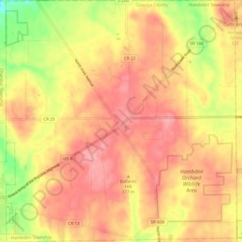
Name: Hambden Township topographic map, elevation, terrain.
Location: Hambden Township, Geauga County, Ohio, United States (41.57051 -81.19118 41.64144 -81.10033)
Average elevation: 1,217 ft
Minimum elevation: 997 ft
Maximum elevation: 1,342 ft
Geauga County trails, hiking, mountain biking, running and outdoor activities
Make a donation
Gear up for your next adventure:
As an Amazon Associate, this site earns from qualifying purchases at no extra cost to you.
Other topographic maps
Click on a map to view its topography, its elevation and its terrain.
Montville
United States > Ohio > Geauga County
A post office called Montville has been in operation since 1825. The area of Montville was named for its lofty elevation.
Average elevation: 1,214 ft
Make a donation
Gear up for your next adventure:
As an Amazon Associate, this site earns from qualifying purchases at no extra cost to you.
Make a donation
Gear up for your next adventure:
As an Amazon Associate, this site earns from qualifying purchases at no extra cost to you.