
Thank you for supporting this site ❤️
Make a donation
Make a donation
Gear up for your next adventure:
As an Amazon Associate, this site earns from qualifying purchases at no extra cost to you.
Zweisimmen topographic map
Click on the map to display elevation.
Thank you for supporting this site ❤️
Make a donation
Make a donation
Gear up for your next adventure:
As an Amazon Associate, this site earns from qualifying purchases at no extra cost to you.
About this map
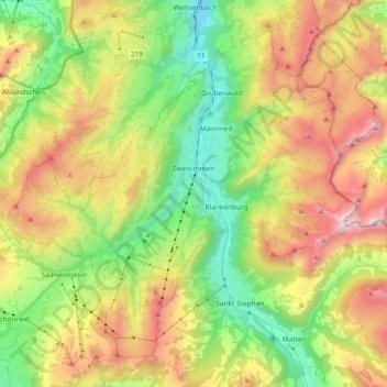
Name: Zweisimmen topographic map, elevation, terrain.
Average elevation: 4,905 ft
Minimum elevation: 2,736 ft
Maximum elevation: 7,982 ft
Thank you for supporting this site ❤️
Make a donation
Make a donation
Gear up for your next adventure:
As an Amazon Associate, this site earns from qualifying purchases at no extra cost to you.
Other topographic maps
Click on a map to view its topography, its elevation and its terrain.
Glacier de la Plaine Morte
Switzerland > Bern > Obersimmental-Saanen administrative district > Mollens (VS)
Average elevation: 8,770 ft