Geolocate

Marrazes topographic map

Click on the map to display elevation.

About this map

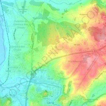
Name: Marrazes topographic map, elevation, terrain.

Location: Marrazes, Leiria, 2415-508, Portugal (39.74260 -8.82593 39.78260 -8.78593)

Average elevation: 230 ft

Minimum elevation: 56 ft

Maximum elevation: 486 ft

Gear up for your next adventure:

🔭Stargazing Telescopes - Perfect for camping in low-light pollution areas shown on maps
🥾Hiking Shoes - Durable and comfortable shoes for trail hiking
🪶Compact Camp Shovel - Folding shovel for campsite tasks
🧣Merino Neck Gaiters - Multi-functional headwear for wind and sun protection
🏕️Family Camping Gear - Essentials for group camping trips

As an Amazon Associate, this site earns from qualifying purchases at no extra cost to you.