Geolocate

Gilbert topographic map

Click on the map to display elevation.

About this map

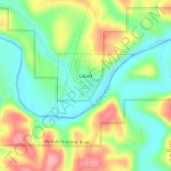
Name: Gilbert topographic map, elevation, terrain.

Location: Gilbert, Searcy County, Arkansas, 72636, United States (35.98466 -92.72184 35.99483 -92.70680)

Average elevation: 709 ft

Minimum elevation: 545 ft

Maximum elevation: 948 ft

Searcy County trails, hiking, mountain biking, running and outdoor activities

Other topographic maps

Click on a map to view its topography, its elevation and its terrain.

Harriet

United States > Arkansas > Searcy County

Average elevation: 965 ft

Gear up for your next adventure:

🔭Stargazing Telescopes - Perfect for camping in low-light pollution areas shown on maps
🧭Map Reading Tools - Tools and kits for map navigation
🎒Trekking Poles - Sturdy poles for balance and stability on rough terrain
🌡️Handheld Weather Meters - Measure wind, temp, and pressure for safe mountain travel
🔦LED Headlamp - Bright and durable LED headlamp for night navigation

As an Amazon Associate, this site earns from qualifying purchases at no extra cost to you.