Geolocate

Pikit topographic map

Click on the map to display elevation.

About this map

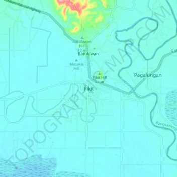
Name: Pikit topographic map, elevation, terrain.

Location: Pikit, North Cotabato, Soccsksargen, 9409, Philippines (7.01374 124.63225 7.09374 124.71225)

Average elevation: 46 ft

Minimum elevation: 10 ft

Maximum elevation: 390 ft

Other topographic maps

Click on a map to view its topography, its elevation and its terrain.

Matalam

Philippines > North Cotabato

Average elevation: 413 ft

New Israel

Philippines > North Cotabato > Makilala

Average elevation: 2,562 ft

Pigcawayan

Philippines > North Cotabato

Average elevation: 436 ft

Makilala

Philippines > North Cotabato

Average elevation: 1,247 ft

Gear up for your next adventure:

🧦Hiking Socks - Comfortable socks to prevent blisters on long hikes
🪑Portable Camp Table - Compact table for campsite meals
🩹Survival Bandages - High‑quality bandages for emergencies
☀️Outdoor Sunscreen - High protection sunscreen for outdoor activities
Backpacking Tent - Lightweight and durable tent for multi‑day hikes

As an Amazon Associate, this site earns from qualifying purchases at no extra cost to you.