Geolocate

Oldham topographic map

Click on the map to display elevation.

About this map

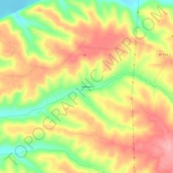
Name: Oldham topographic map, elevation, terrain.

Location: Oldham, Oldham County, Kentucky, 40077, United States (38.47756 -85.44107 38.51756 -85.40107)

Average elevation: 686 ft

Minimum elevation: 436 ft

Maximum elevation: 883 ft

Oldham County trails, hiking, mountain biking, running and outdoor activities

Other topographic maps

Click on a map to view its topography, its elevation and its terrain.

Goshen

United States > Kentucky > Oldham County

Average elevation: 669 ft

La Grange

United States > Kentucky > Oldham County

Average elevation: 807 ft

Goshen

United States > Kentucky > Oldham County

Average elevation: 669 ft

La Grange

United States > Kentucky > Oldham County

Average elevation: 807 ft

Crestwood

United States > Kentucky > Oldham County

Average elevation: 732 ft

Gear up for your next adventure:

🧤Tactile Hiking Gloves - Keep hands warm while operating GPS and smartphone screens
🔭Telescopic Hiking Pole - Adjustable pole for hiking stability
🔌USB Car Charger - Car charger for on‑the‑go power needs
🌡️Handheld Weather Meters - Measure wind, temp, and pressure for safe mountain travel
🥾Women's Hiking Boots - Top-rated trail boots with ankle support and superior grip

As an Amazon Associate, this site earns from qualifying purchases at no extra cost to you.